top of page

NRT Digital Twin Features
Creat intelligent digital roads and manage the real roads
V2X Digial Twin Real Time Detection
Based on the 3D GIS map of the highway and combined with the project design and construction drawings, engineed by sensors technology NRT achieves V2X digital applications.
Highway Construction Project Management

Based on the 3D GIS map of the highway and combined with the project design and construction drawings, a comprehensive, accurate and refined construction management platform is created. Greatly improve the visualization and accuracy level of highway engineering projects.
Features
As-Built Visualization
-
View the effect of the project after completion.
Live Site Feed
-
Access Video Data to View Real-Time Construction Site.
Construction Progress Display
-
View the overall construction progress of the project
Structural Monitoring for Slopes, Bridges and Tunnels

Critical Tunnel Structural Monitoring

Critical Bridge Structural Monitoring

Critical Slope Structural Monitoring
Collect structural health monitoring data (deformation, cracks, etc.) via sensors, and implement visual management through 3D GIS mapping to enable real-time facility condition assessment by operators.
Patrol & Maintenance Management
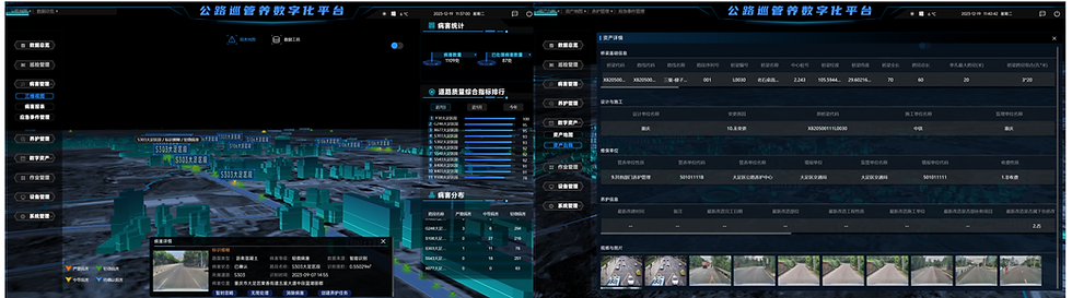

3D GIS-Driven Highway Patrol & Maintenance Management System
Integrated pavement distress data (cracking, potholes, subsidence risks) into the 3D GIS map for centralized defect governance. Core functionalities include:
-
Pavement condition index (PCI) analytics
-
Defect distribution heatmap visualization
-
Automated maintenance work order generation via digital twin integration
-
Full lifecycle oversight from defect detection to repair verification
Reconstruction & Expansion Design

Map-Enabled Scenario Planning Module for rapid traffic management scheme design with simulation capabilities to visualize post-implementation impacts, facilitating technical review and stakeholder presentations.
Features
Construction Area Design
-
View the effect of the project after completion.
Vehicle Traffic Effect Simulation
-
Access Video Data to View Real-Time Construction Site.
Traffic Efficiency Assessment
-
View the overall construction progress of the project.
Operational Status Monitoring

Real-Time Traffic Data Fusion & Analytics:Integrate multi-source sensor inputs (surveillance cameras, radar-video integrated devices, floating vehicle data) to collect, process, and dynamically visualize traffic flow dynamics with AI-powered congestion pattern recognition.
Features
-
Multi-source data fusion
-
Accurate calculations
-
Heatmap visualization
-
Integrated Management
Highway Asset


Other Applications

As foundational infrastructure for digital transportation development, the 3D GIS map for highways will serve more information systems and operational scenarios, helping managers establish unified, efficient, and precise management models, while also creating a better travel environment for commuters.
bottom of page